|
General Information on the Fire Weather System Of Georgia Forestry
Commission Weather
Forecast Georgia
Forestry Commission's (GFC) used National Weather Service’s (NWS)
Fire Weather Dashboard to get to weather products produced by the
NWS. GFC
produces observed or forecast weather maps/graphs. GFC also generates current and forecast
fire danger rating information for GFC and co-operators weather station
network. Other products available
through GFC's Fire Weather Homepage (https://weather.gfc.state.ga.us)
include Current weather at National Weather Service's (NWS) weather stations
in Georgia, historical data from the GFC weather stations, and a climate outlook
from NWS's Climate Prediction Center. NFDRS NFDRS
stands for National Fire Danger Rating Systems. The current version of the National Fire
Danger Rating System was developed by the US Forest Service (Burgan, 1988)
for predicting fire occurrence and behavior based on fuels, topography, man‑caused
fire risk factors and current weather conditions. Although the National Fire
Danger Rating System indices should not be directly applied to any particular
site, they do supply the practitioner with a set of indices that can be used
to compare recent history, and adjacent fire management areas. Thus, it is very important to understand
the principles of fire danger rating:
Experienced
practitioners can translate these general area based indices to probable fire
behavior at specific burn site.
Detailed explanation of the fire danger indices can be found by
clicking "Explanation of NFDRS Indices" on the fire weather
homepage. Weather
data are input into NFDRS and a number of indices are produced. These fire danger indices are used to
support prescribed burning activities and wildfire control operations. Weather data are collected automatically
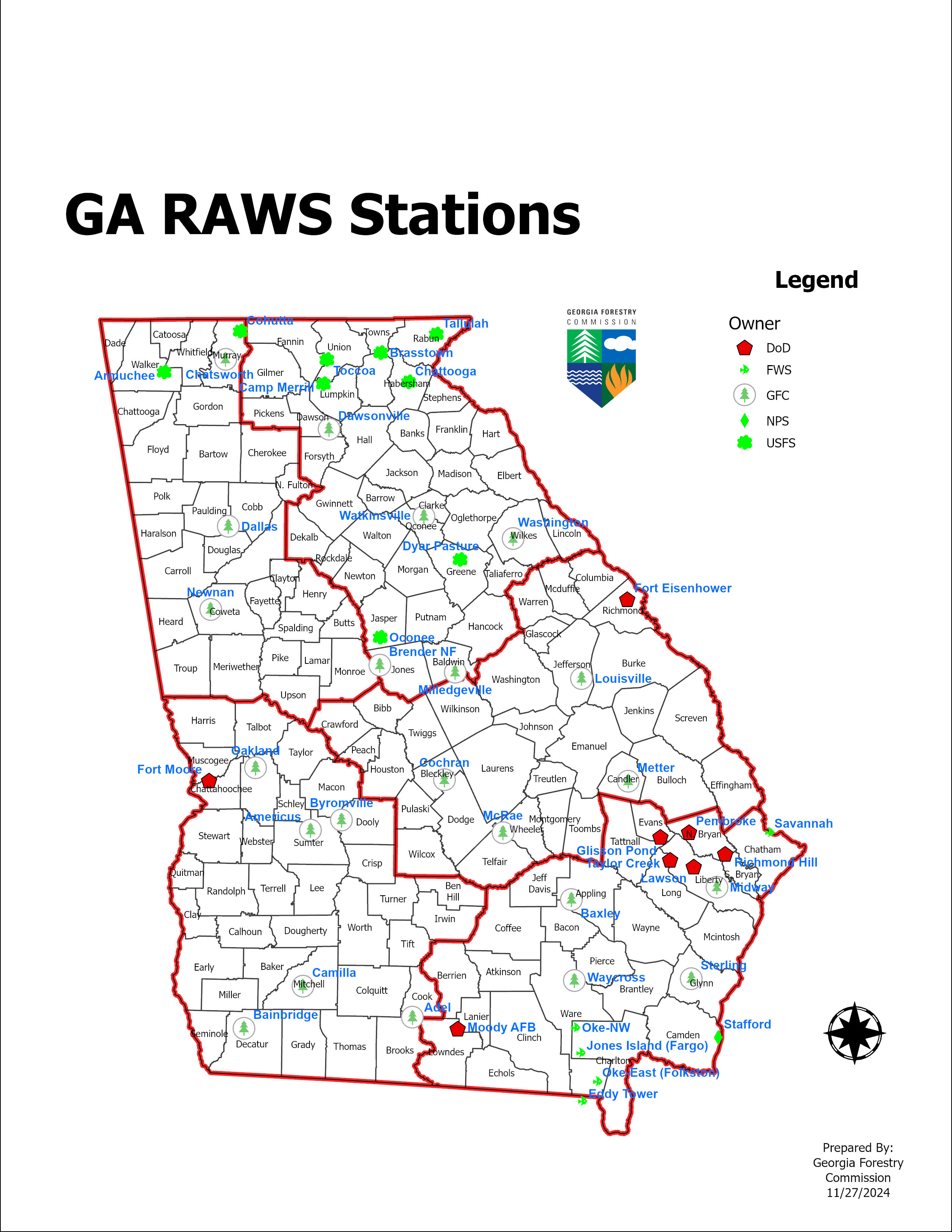
daily at Weather Station Network GFC operates a network of
19 automated weather stations throughout the state (Figure 1). The stations record current weather
conditions each hour. Weather data
from stations maintained by cooperating agencies, including US Forest
Service, US Park Service, Department of Defense and
GFC currently uses NFDRS
fuel models C, D, and E. Definitions
of the various fuel models are included in (Appendix A). Location and fuel model associated with
each station is shown in Table 1. The
Georgia Forestry Commission uses Burning Index (BI) to determine Class Day. The determination points are station
specific based on BI percentile distribution at the station. The BI determination points for all the
stations are listed in Table 2. Table 3 shows the Energy Release Component
(ERC) percentile points for all stations.
Table 1.
Name, location, elevation, and NFDRS fuel model used for the weather
stations accessed by the GFC (excluding UGA stations)
Notes: The abbreviations are
noted below. GFC - Georgia Forestry Commission DoD - Department of Defense FWS - NPS
- U.S Department of Interior,
Park Service USFS
- All
Locations are North latitude and West(-) longitude. Table
2: Class Day determination points
Note: The listed values are the minimum value for
each Class day. For example, when
Americus has BI of 22-24, it has Class 4 Day.
Table
3: Energy Release Component (ERC) Percentiles
Note: The listed values are the minimum value for
each Percentile range. For example,
when Americus has ERC of 22-25, it between 90th and 97th
percentile. REFERENCES Deeming, John E.; Burgan, Robert
E.; Cohen, Jack D. The National Fire-Danger Rating System – 1978. 1988
Revisions to the 1978 National Fire-Danger Rating System. General Technical Report INT-39. Paul, J.T., and J. Clayton. User manual: Forestry Weather Interpretation System
(FWIS). Asheville, NC: U.S. Department
of Agriculture, Forest Service, Southeastern Forest Experiment Station and
Atlanta, GA: Southeastern Area State
and Private Forestry, in cooperation
with the U.S. National Weather Service, NOAA, Silver Spring, M;. 1978. 83pp. APPENDIX
A FUEL MODEL DEFINITIONS Definitions extracted from (Deeming, et
al. 1977). FUEL MODEL A This fuel model represents western grasslands vegetated by
annual grasses and forbs. Brush or trees may be present but are very sparse,
occupying less than one third of the area. Examples of types where Fuel Model
A should be used are cheatgrass and medusahead. Open pinyon-juniper, sagebrush-grass, and
desert shrub associations may appropriately be assigned this fuel model if
the woody plants meet the density criteria. The quantity and continuity of
the ground fuels vary greatly with rainfall from year to year. FUEL MODEL B Mature, dense fields of brush 6 feet or more in height are
represented by this fuel model. One-fourth or more of the aerial fuel in such
stands is dead. Foliage burns readily. Model B fuels are potentially very
dangerous, fostering intense, fast-spreading fires. This model is for FUEL MODEL C Open pine stands typify Model C fuels. Perennial grasses and
forbs are the primary ground fuel but there is enough needle litter and branchwood present to contribute significantly to the
fuel loading. Some brush and shrubs may be present but they are of little
consequence. Situations covered by Fuel Model C are open, longleaf, slash,ponderosa,Jeffrey, and
sugar pine stands. Some pinyon-juniper stands may qualify. FUEL MODEL D This fuel model is specifically for the palmetto-gallberry understory-pine overstory
association of the southeast coastal plains. It can also be used for the
so-called "low pocosins" where Fuel Model
0 might be too severe. This model should only be used in the Southeast
because of a high moisture of extinction. FUEL MODEL E Use this model after leaf fall for hardwood and mixed hardwood-conifer
types where the hardwoods dominate. The fuel is primarily hardwood leaf
litter. The oakhickory types are best represented
by Fuel Model E, but E is an acceptable choice for northern hardwoods and
mixed forests of the Southeast. In high winds, the fire danger may be
underrated because rolling and blowing leaves are not accounted for. In the
summer after the trees have leafed out, Fuel Model E should be replaced by
Fuel Model R FUEL MODEL F Fuel Model F is the only one of the 1972 NFDRS Fuel Models whose
application has changed. Model F now represents mature closed chamise stands and oakbrush
fields of FUEL MODEL G Fuel Model G is used for dense conifer stands where there is a
heavy accumulation of litter and downed woody material. Such stands are
typically overmature and may also be suffering
insect, disease, wind, or ice damage-natural events that create a very heavy
buildup of dead material on the forest floor. The duff and litter are deep
and much of the woody material is more than 3 inches in diameter. The
undergrowth is variable but shrubs are usually restricted to openings. Types
meant to be represented by Fuel Model G are hemlock-Sitka spruce, Coast
Douglas-fir, and windthrown or bug-killed stands of
lodgepole pine and spruce. FUEL MODEL H The short-needled conifers (white pines, spruces, larches, and
firs) are represented by Fuel Model H. In contrast to Model G fuels, Fuel
Model H describes a healthy stand with sparse undergrowth and a thin layer of
ground fuels. Fires in H fuels are typically slow spreading and are dangerous
only in scattered areas where the downed goody material is concentrated. FUEL MODEL I Fuel Model I was designed for clearcut
conifer slash where the total loading of materials less than 6 inches in
diameter exceeds 25 tons/acre. After settling and the fines (needles and
twigs) fall from the branches, Fuel Model I will overrate the fire Potential.
For lighter loadings of clearcut conifer slash, use
Fuel Model J, and for light thinnings and partial
cuts where the slash is scattered under a residual overstory,
use Fuel Model K. FUEL MODEL J This model complements Fuel Model I. It is for clearcuts and heavily thinned conifer stands where the
total loading of materials less than 6 inches in diameter is less than 25
tons/acre. Again, as the slash ages, the fire potential will be overrated FUEL MODEL K Slash fuels from light- thinnings and
partial cuts in conifer stands are represented by Fuel Model K. Typically the
slash is scattered about under an open overstory.
This model applies to hardwood slash and to southern pine clearcuts
where the loading of all Fuels is less than 15 tons/acre. FUEL MODEL L This fuel model is meant to represent western grasslands
vegetated by perennial grasses. The principal species are coarser and the
loadings heavier than those in Model A fuels. Otherwise the situations are
very similar; shrubs and trees occupy less than one-third of the area. The
quantity of fuel in these areas is more stable from year to year. In
sagebrush areas Fuel Model T may be more appropriate. FUEL MODEL N This fuel model was constructed specifically for the sawgrass
prairies of south FUEL MODEL O The O fuel model applies to dense, brushlike
fuels of the Southeast. O fuels, except for a deep litter layer, are almost
entirely living in contrast to B fuels. The foliage burns readily except
during the active growing season. The plants are typically over 6 feet tall
and are often found under an open stand of pine. The high pocosins
of the FUEL MODEL P Closed, thrifty stands of long-needled southern pines are characteristic
of P fuel: A 2- to 4-inch layer of lightly compacted needle litter is the
primary fuel. Some small diameter branchwood is
present but the density of the canopy precludes more than a scattering of
shrubs and grass. Fuel Model P has the
high moisture of extinction characteristic of the Southeast. The
corresponding model for other long-needled pines is U. FUEL MODEL Q Upland Alaskan black spruce is represented by Fuel Model Q. The
stands are dense but have frequent openings filled with usually inflammable
shrub species. The forest floor is a deep layer of moss and lichens, but
there is some needle litter and small-diameter branchwood.
The branches are persistent on the trees, and ground fires easily reach into
the tree crowns. This fuel model may be useful for jack pine stands in the
Lake States. Ground fires are typically slow spreading, but a dangerous
crowning potential exists. Users should be alert to such events and note
those levels of Spread Component (SC) and BI when crowning occurs. FUEL MODEL R This fuel model represents the hardwood areas after the canopies
leaf out in the spring. It is provided as the off-season substitute for E. It
should be used during the summer in all hardwood and mixed conifer-hardwood
stands where more than half of the overstory is
deciduous. FUEL MODEL S Alaskan or alpine tundra on relatively well-drained sites is the
S fuel. Grass and low shrubs are often present, but the principal fuel is a
deep layer of lichens and moss. Fires in these fuels are not fast spreading
or intense, but are difficult to extinguish. FUEL MODEL T The bothersome sagebrush-grass types of the FUEL MODEL U Closed stands of western long-needled
pines are covered by this model. The ground fuels are primarily litter and
small branchwood. Grass and shrubs are precluded by
the dense canopy but occur in the occasional natural opening. Fuel Model U
should be used for ponderosa, Jeffrey, sugar pine, and red pine stands of the
Lake States. Fuel Model P is the corresponding model for southern pine
plantations. |
|||||||||||||||||||||||||||||||||||||||||||||||||||||||||||||||||||||||||||||||||||||||||||||||||||||||||||||||||||||||||||||||||||||||||||||||||||||||||||||||||||||||||||||||||||||||||||||||||||||||||||||||||||||||||||||||||||||||||||||||||||||||||||||||||||||||||||||||||||||||||||||||||||||||||||||||||||||||||||||||||||||||||||||||||||||||||||||||||||||||||||||||||||||||||||||||||||||||||||||||||||||||||||||||||||||||||||||||||||||||||||||||||||||||||||||||||||||||||||||||||||||||||||||||||||||||||||||||||||||||||||||||||||||||||||||||||||||||||||||||||||||||||||||||||||||||||||||||||||||||||||||||||||||||||||||||||||||||||||||||||||||||||||||||||||||||||||||||||||||||||||||||||||||||||||||||||||||||||||||||||||||||||||||||||||||||||||||||||||||||||||||||||||||||||||||||||||||||||||||||||||||||||||||||||||||||||||||||||||||||||||||||||||||||||||||||||||||||||||||||||||||||||||||||||||||||||||||||||||||||||||||||||||||||||||||||||||||||||||||||||||||||||||||||||||||||||||||||||||||||
|
|